
home page
what's new?
email bobtrubs@indigogroup.co.uk
to request updates
(please mention
Rutland Village by Village)
or to offer new information
Village by Village
AshwellAyston
Barleythorpe
Barrow
Barrowden
Beaumont Chase
Belmesthorpe
Belton-in-Rutland
Bisbrooke
Braunston-in-Rutland
Brooke
Burley
Edith Weston
Egleton
Empingham
Essendine
Exton
Glaston
Great Casterton
Greetham
Gunthorpe
Langham
Leighfield
Little Casterton
Lyddington
Lyndon
Manton
Market Overton
Martinsthorpe
Morcott
Seaton
South Luffenham
Stoke Dry
Stretton
Teigh
Thistleton
Thorpe by Water
Tickencote
Tinwell
Tixover
Wardley
Whissendine
Whitwell
Wing

North and South Luffenham
North and South Luffenham straddle the River Chater five miles east of Uppingham and seven miles west of Stamford.The name is derived from 'Luffa's estate'. Luffa was a male Anglo-Saxon name.
However an Anglo-Saxon charter spells the name as something like 'lough ham' (some letterforms are ambiguous). However lough, signifying a lake or sea inlet, is only found in Irish and Northern English and is absent from Old English. So I think this 'lough ham' was pronounced to rhyme with 'cough' (as in clearing one's throat, not the bird).
North and South Luffenham were in Wrangdike Hundred.
In 2016 Wessex Archaeology did an archaeological evaluation at St George's Barracks, North Luffenham. Round houses, pits and ditches and Iron Age and Roman material were found.
A large pagan Anglo-Saxon cemetery to the north of village included what seem to be Roman military metalwork from Germanic foederati and at least ten swords, which is exceptional. Possibly these were burials of house curls of the mid-Anglian royal estate, perhaps associated with Eadgyd ('Edith') of Edith Weston. (Nick Cooper pers. comm. 1991.)
A fragment of a late ninth or tenth century cross shaft was discovered built into the wall of a barn near South Luffenham church. The building has been converted to a dwelling and the carving is now inside. One face depicts Adam and Eve under a tree. It is illustrated and discussed in Rosemary Cramp, Jane Hawkes and Joanna Storey Corpus of Anglo-Saxon Stone Sculpture Vol.15 East Midlands (British Academy 2026).
A harstone (boundary stone) is referred to in 1631 and throughout the eigtheenth century. A large stone, allegedly this 'boundary marker', is known to have been moved in the 1950s to provide somewhere to sit while smoking cigarettes. (Debbie Frearson pers comm. 2009.)

Looking at the River Chater from the footbridge between the two settlements.
Both villages are situated on a probable Roman road running south from Empingham. Part of this survives to the east of Normanton but most was lost to North Luffenham airfield. Between the two settlements there is now a footbridge over the River Chater but historically there would have only been a ford.
In Anglo-Saxon times, and presumably earlier, the Chater valley was a lake with water levels up to three metres higher than at present. There is a record of a 'hempyard' on the shore of this one-time lake. This would be a place for growing hemp. However in the 1970s seemingly the Hempyard was also known as the Ropewalk. I suspect some of the hemp grown in the hempyard was indeed made into rope at the ropewalk. But the hempyard and the ropewalk were probably originally two different (but maybe adjacent) places.
According to a booklet published in 1977:
-
There is a tradition in the village that sea-going boats once came up the Foss to a quay by the old village pond, and were unloaded by monks from a monastery below the church. The stream was thought to be a canal, when the sea came up to Uffington, and was quite deep until the water backed up and silted-in the race to provide power at the watermill. The Chater was said to be six feet deep at the washdyke.
North Luffenham
The deserted medieval settlement of Sculthorpe is now in North Luffenham parish but was historically in Pilton.In a small wood on the crest of a ridge on the parish boundary with Morcott is an artificial mound about two to three metres high. Various explanations have been offered, from an Anglo-Saxon burial mound, a small Norman castle, to a gun emplacement for the Civil War siege of North Luffenham Hall. Most probably it is a 'prospect mound' created in the seventeenth century to provide a vantage point for looking at the park.
North Luffenham Hall (until 1806 known as Digby House) is a sixteenth century manor house with a timber-framed tithe barn dated 1555 adjacent. It was extended in 1910–11.

To the south-west of the church is a large semi-circular ha-ha, built in the middle of the eighteenth century as part of the gardens of Luffenham House, which was demolished in 1806. Photograph taken in 2001.
Probably also part of these gardens are earthworks that may have been ornamental fishponds but originated as a moat around the since-demolished Old Hall.

North Luffenham in 1884. The church and a pinfold are highlighted in red.
A house known as 'Pastures House', on the road to Morcott, was built in 1901 and is an example of the work of the nationally-important architect and designer Charles Voysey (1857–1941). His houses were characteristically asymmetrical with massive supporting walls, rough-cast walls and long sloping roofs. More details here.
St John the Baptist's church
Before I discuss the present building, I want to outline why North Luffenham seems to be the location of one of the very earliest churches in Rutland and Leicestershire. It could be late seventh or early eighth century. While the Luffenhams now seem to be quiet backwaters that was not the case then. For reasons unknown the estate centre previously based at Hambleton relocated to what is now North Luffenham (South Luffenham only came into existence later). It may be because an estate associated with the Roman villa a short distance downstream along the Chater near Ketton still existed and Luffenham was the most suitable place to administer it from.The location at the then-limits of navigation for the River Chater and the presence of a ford for a Roman north-south routeway was almost certainly decisive. Most of the earliest churches away from the coast are at such locations. Fords are not only important for crossing watercourses but they also allow flat-bottomed watercraft to be 'beached' for unloading.
In the late eleventh century the Normans moved the administrative centre to Oakham and built a castle there. Luffenham faded into obscurity while Oakham thrived.
Another clue as to the early religious importance of Luffenham is a mention in the early thirteenth century of a field called 'Middlestow'. Old English stow almost always denoted a religious place, though not necessarily a church. Whether there was a 'Northstow', 'Southstow', 'Eaststow' or 'Weststow' will probably never be known. They might have been thought of as a stow but actually had quite different names. Plausibly the site of St John's church was one of these stows.
What we see today when visiting St John the Baptist's church is lots of late thirteenth and early fourteenth century masonry. However it was heavily restored between 1870 and 1875 leaving the interior rather unattractive.
The north arcade is late twelfth century and the south arcade followed a few decades later.
There are traces of thirteenth century wall paintings and much fourteenth century glass in the chancel windows.
The nave roof is fifteenth century with a multitude of angels and bosses which retain their original colour. The impressive sedilia is also fifteenth century.
The pulpit is sixteenth century.
There are monuments to members of the Digby family and a portrait bust of Susanna Noel, who died in 1640.
The nave roof is supported by figurative corbels and wooden angels. Some lively faces decorate the arches on the south side of the nave.

One of the enigmatic faces dating from the 1870s restoration of North Luffenham church.
Victoria County History page for North Luffenham.
South Luffenham
The meeting place of the Wrangdike Hundred may have been at South Luffenham at a place recorded in 1277 as Wrogeditch ('crooked or bent ditch').South Luffenham developed at a ford over the River Chater. However the part south of the river was only created in 1850 around the first railway junction in Rutland.
However the village was on earlier transport routes as a Salter's Cross is recorded in 1615, which alludes to one of the many former salt ways crossing Rutland and Leicestershire in a roughtly east-west direction. The probably originate as Neolithic transhumance routes from the Fens to higher ground such as High East Leicestershire and Charnwood Forest.
There is a seventeenth century farmhouse near the church. South Luffenham Hall, to the south of the church, is also seventeenth century.
A number of interesting small stone-built barns survive amidst the houses, and early eighteenth century stables.
The pinfold was used until the 1890s. It was at the south end of Pinfold Lane (see map above) with six-foot high walls and an iron gate. Most of it was demolished in 1910, although part of the wall survived in 1977. In the 1970s one farmer recalled walking his sheep from Ayston to Stamford market and resting the sheep in the pinfold overnight.
A watermill operated on the River Chater from before Domesday until 1948.
South Luffenham's Grade II listed stone tower mill was built near Station Road in 1832 (according to the datestone over the door) using coursed rubble stone with red brick details. Unusually this was built on comparatively low-lying ground. It was operational until 1908, even after a storm blew off its top in 1895. This suggests that a steam engine was being used by 1895.
St Mary's church
St Mary's church has a late twelfth century Romanesque north arcade with exceptionally wide arches. The decoration of the capitals is fascinating and includes a hare and various faces, one of which sports a moustache.

The capitals at South Luffenham appear to have been carved by the same masons who worked at Morcott.
The south arcade is thirteenth century, while the tower and curiously crocketed spire are fourteenth century; the gargoyles are especially prominent.
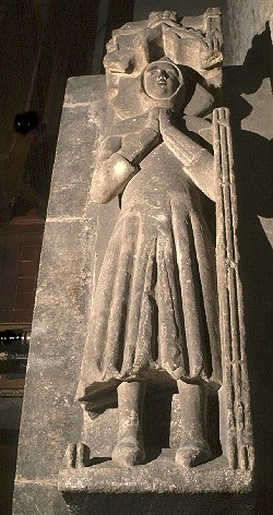
The chancel is fifteenth century, with a well-preserved fourteenth century effigy of a priest, seemingly a member of the Culpepper family.
The 'dug out' medieval parish chest is one of four in Rutland.
The nave is dominated by an ugly round stone pulpit carved in 1861; it has been dubbed the 'parson cooler'.
A bell dated 1588 was one of the oldest in the district until it was recast in 1861.
Victoria County History page for South Luffenham.
Back to top of this page Back to home page
This website does not gather or store any visitor information.
Copyright Bob Trubshaw 2026
No unauthorised copying
or reproduction except if all following conditions apply
a: Copy is complete (including this copyright statement).
b: No changes are made.
c: No charge is made.
Rutland's history
home page
long, long ago
long ago
- Anglo-Saxon Rutland
- Rutland's place-names
- waterborne transport around the sixth century
- Rutland's early churches
- Anglo-Saxon sculpture in Rutland
- The Matter of Rutland
- what the Normans did for Rutland
- Romanesque sculpture in Rutland
- Rutland in medieval times
- Rutland's scratch dials
- Rutland's medieval carvings
- Rutland's sepulchral effigies
- Rutland's saltways
- Rutland in Tudor times
- Dissolution in Rutland
not that long ago
- Rutland in the 17th century
- pinfolds and pounds in Rutland
- dovecotes in Rutland
- Rutland in the 18th century
- turnpiking Rutland
- Rutland's springs and wells
- changes in Rutland's agriculture since 1800
seems like yesterday
- Rutland's dialect
- Rutland's folk customs
- travellers in Rutland
- watermills and windmills in Rutland
- breweries in Rutland
- gasworks in Rutland
- ironstone quarrying in Rutland
- Zeppelins over Rutland
- redundant telephone exchanges in Rutland
- Second World War in Rutland
- WWII airfields and pillboxes in Rutland
- the making of Rutland Water
- Rutland Weekend Television
free online history resources
- Victoria County History: Rutland volume one
- Victoria County History: Rutland volume two
- free PDFs of Rutland Record issues 1 to 50
- old OS maps
- Historic England Listed buildings database
- Sepulchral Effigies of Leicestershire and Rutland
- Open Domesday
- English Place-Name Society database
- Wikipedia list of places in Rutland (with links to village entries)
- Wikipedia list of people from Rutland
researching and writing local history
- getting started free advice from 2005
- asking curious questions (YouTube video)
local history groups in and around Rutland
- Belton-in-Rutland History Society
- Cottesmore History and Archaeology Group
- Langham Village History Group
- Lyddington Manor History Society
- Rutland Local History and Record Society
- Uppingham Local History Study Group
you may also be interested in
free PDFs written by Bob Trubshaw
Bob Trubshaw's YouTube channel
Sepulchral Effigies of Leicestershire and Rutland